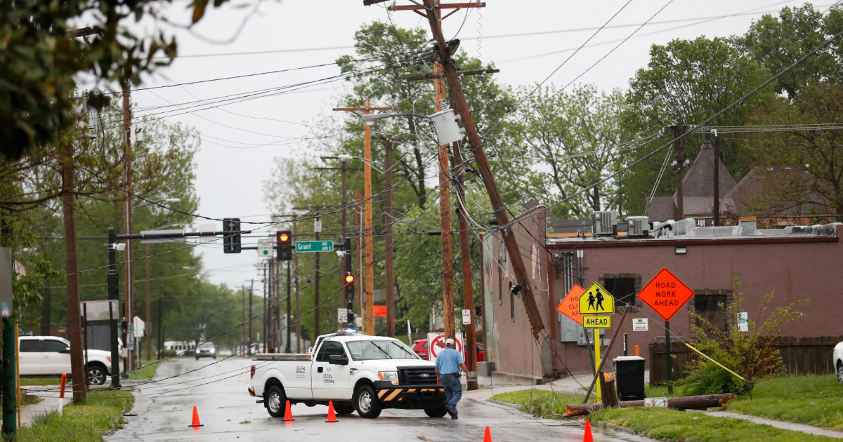
- The National Weather Service in Springfield, Missouri, is assessing damage from likely tornadoes and severe winds.
- Wind gusts of up to 90 mph were recorded, causing widespread damage including downed trees and power lines.
- Further rounds of thunderstorms are expected through Thursday, with potential for flooding and more severe weather.
The National Weather Service will be assessing damage in the Springfield area due to tornadoes and severe winds for the next few days, according to Kelsey Angle, the meteorologist in charge at the Springfield office. But the threat of severe weather isn’t over yet, he said.
Multiple rounds of showers and thunderstorms over the next few days could bring flooding to the area.
“We have chances for showers and thunderstorms that continue through Thursday, with that, the potential for some strong to severe thunderstorms through Thursday,” Angle said. “As we go through the week, we’ll also have to monitor the potential for flooding very closely as well.”
NWS to assess damage from likely tornadoes, damaging winds
The morning of Tuesday, April 29, the NWS Facebook page reported likely tornadoes on the ground northeast of Freemont Hills moving toward Rogersville at 9:38 a.m. A tornado warning was issued at 9:20 a.m. and extended through 10:15 a.m. Tuesday morning.

“With the winds that we’ve had across the area, particularly Springfield and Greene County, there’s going to be widespread damage, which will include broken tree branches, some trees uprooted and any tornado damage is going to be very, very localized. We’ll be doing damage assessments accordingly,” Angle said.
The NWS office in Springfield, near the Springfield-Branson airport, recorded 90 mph wind gusts. Damaging winds ranged from 60 to 90 mph.
Angle encouraged people to continue to monitor multiple channels of weather information, especially during this time of year.
“It’s important as we head through spring and the early summer months that you maintain weather awareness. Ways to do that are through the National Weather Service website, through radio and television, and NOAA Weather Radio,” Angle said. “It’s important to have multiple ways to receive the warning information so that you can keep yourself and your family safe.”

More: Use our interactive map to see storm impacts in Springfield
Outages, blocked roadways, safety concerns following severe weather
Based on the City Utilities outage map, there are 80 active outages impacting about 838 customers as of 11 a.m.
Interim City Manager Colin Quigley said at Tuesday’s Springfield City Council lunch that about 16,000 customers are currently without power. Quigley also said that people can call the Citizen Resource phone line, 417-864-1010, to report downed trees.
At 10 a.m., the City of Springfield posted on Facebook asking people to stay off the roads as there were “a lot of downed power lines and trees making travel hazardous.” The Springfield Police Department also posted around 11 a.m. that officers are responding to “blocked roadways that may cause traffic safety concerns as well as any damaged structures where someone may be injured” and asked citizens to stay home.

“We can confirm the Fire Department is responding to situations that are to be expected with a storm of this size. That includes: downed power lines and fire response,” said Cora Scott, City of Springfield spokesperson, via text. “Springfield Police Department is responding to blocked roadways and damaged structures. At this time, we are still assessing damage.”
(This story was updated with additional information.)