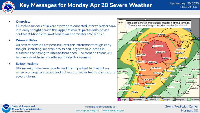
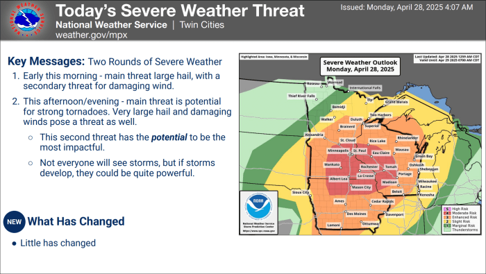
Monday is poised to be a severe weather day in Minnesota, Wisconsin and Iowa as a potent storm system collides with potentially ideal atmospheric conditions, setting the stage for storms that could produce strong tornadoes, damaging winds and very large hail.
3:45 p.m. Tornado warning in Stearns, Wright and Meeker County
A radar-indicated tornado warning has been issued for an area of Stearns, Wright and Meeker counties that includes Kimball, Clearwater and Watkins in central Minnesota.
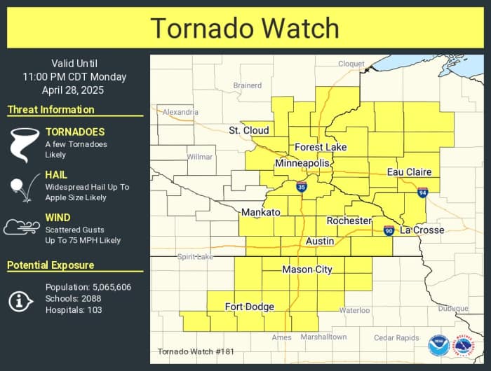
3:30 p.m. – TORNADO WATCH ISSUED FOR TWIN CITIES
It was expected, and now it has been confirmed as the tornado watch for Minnesota expands east, including the Twin Cities metro and southeastern Minnesota, with the highest risk of strong tornadoes expected in the latter.
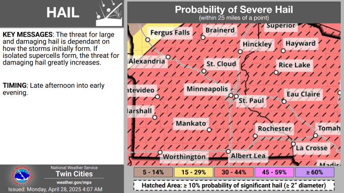
The watch states that apple-sized hail (!) is possible, wind gusts of up to 75 mph, and a few tornadoes are “likely.”

3:25 p.m. – Storm radar update for the Twin Cities
Here’s the latest update from the NWS Twin Cities, which shows that the metro area is still in line for potentially severe thunderstorms Monday evening. As things stand, the highest risk of tornadoes is to the south of the metro area, but the line of storms currently in south and central Minnesota have the potential to intensify as they move closer to the Twin Cities.
3:20 p.m. – More event cancellations in Twin Cities
Minneapolis has already closed most of its city offices for the day, and a number of other cities are taking precautionary steps ahead of the weather.
The latest:
- Brooklyn Park has canceled its city meetings scheduled for tonight, and closed its city buildings as of 3 p.m.
- The City of Plymouth has canceled its recreation programming and classes.
- Minneapolis Parks and Rec board has canceled its programming and classes.
2:55 p.m. – BMTN in southeast Minnesota
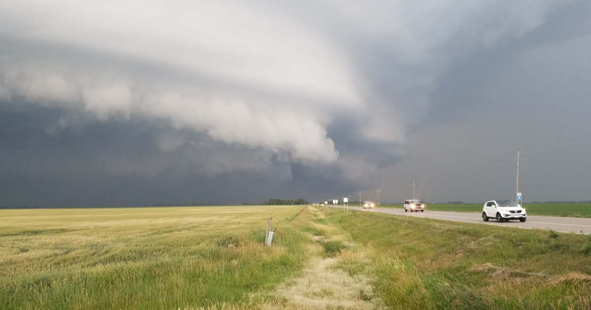
Here’s Bring Me The News co-owner Joe Nelson just west of St. Peter in southeastern Minnesota, where the wind is already picking up.

2:40 p.m. – Tornado warning in southwest Minnesota
The first tornado warning of the day in Minnesota has been issued in southwest Minnesota, and is in effect till 3 p.m. Residents are advised to take cover in a basement.
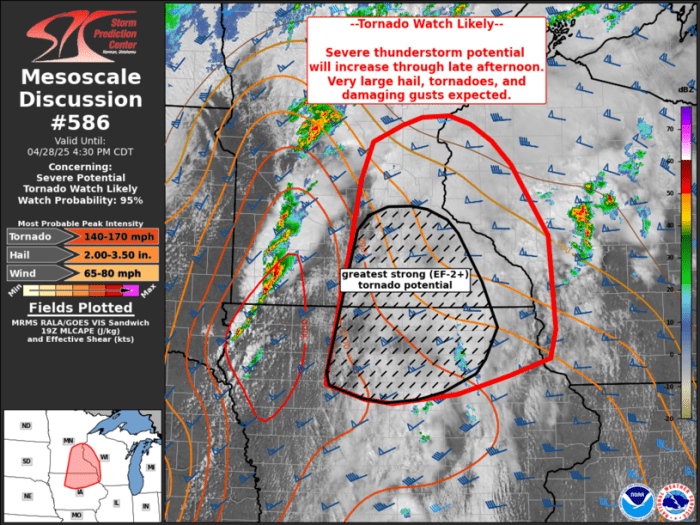
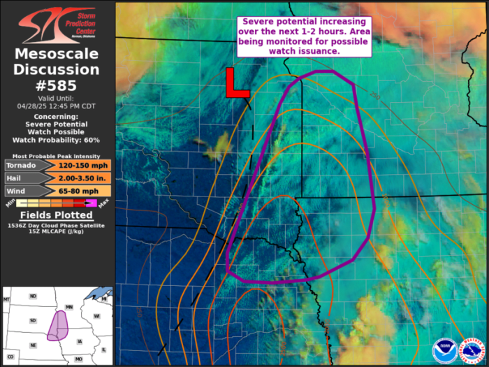
2:35 p.m. – SPC says 140-170 mph tornadoes possible
A “concerning” update from the National Weather Service’s Storm Prediction Center (SPC), which says that there’s a 95% chance of a tornado watch in southeastern Minnesota and the Twin Cities later this afternoon.
The highest risk of strong tornadoes is in the south and southeast of the state, an area that includes Rochester, Mankato, Faribault and Albert Lea, and potentially reaching the southern 7-county metro.
“Intense convection is expected to move across the MCD (Mesoscale Discussion area) from late this afternoon into this evening, posing an all-hazards severe risk. A tornado watch will likely be needed in the next 1-2 hours,” the SPC says.

The hazards? That includes a peak tornado intensity of 140-170 mph, peak wind gusts of 65-80 mph, and peak hail size of between 2 and 3.5 inches.
NWS SPC
2:10 p.m. – Large hail on the ground in SW Minnesota
Here’s a closer look at what the storm system currently making its way across Minnesota is bringing with it, courtesy of storm-chaser Dan Whittaker.
2:05 p.m. – NWS says ‘all hazards possible’ in latest update
The NWS updated its forecast discussion for the Twin Cities region shortly before 2 p.m., saying that “all hazards” remain in play as the severe storm system moves east.
“The storms across E SD/SW MN will continue to intensify over the next few hours with a few becoming severe capable of producing damaging winds/large hail/tornadoes,” it says.
“Hi-res guidance has remained inconsistent with what exactly evolves this afternoon. Current forecast thoughts suggest we’ll see a line of embedded supercells form and track from W MN to S MN over the next several hours,” it adds. “These storms will be in the ‘best’ environment capable of supporting all severe hazards, including potential for a strong tornadoes.
“These storms may cycle and continue to produce severe as they track ENE. Central Minnesota and western Wisconsin remain in play.
“These storms should be capable of producing damaging wind, large hail, and a tornado or two as well but the better environment for tornadoes is across S MN/N IA.”
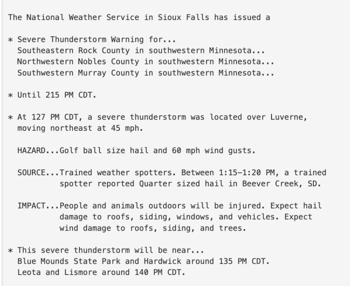
1:55 p.m. – Severe thunderstorm warnings expand east
As the severe system moves east, severe thunderstorm warnings are going with it. The latest warning is for northeastern Rock, northwestern Nobles and southwestern Murray County in southwest Minnesota.
“At 1:42 p.m., a severe thunderstorm was located near Blue Mounds State Park, or 7 miles northeast of Luverne, moving northeast at 40 mph,” the warning reads.
The main hazard from the storm is “golf ball size hail and 60 mph wind gusts,” with officials warning people and animals outdoors could be injured, and hail and wind could damage roofs, windows, trees and siding.
1:40 p.m. – Well-known storm chaser is in the Midwest
Reed Timmer, well-known storm chaser and extreme meteorologist, was in Sioux Falls, South Dakota earlier as he prepares for the severe weather, which is now making its way across southwestern Minnesota.
He says that supercells are possible between 2-3 p.m. in southern Minnesota and northern Iowa, that has the potential to produce strong or violent tornadoes.
1:25 p.m. – Tornado watch expected in Twin Cities later
The first severe thunderstorm warning of the day in Minnesota has been issued, with the NWS Sioux Falls saying the warning is in effect in Beaver Creek in southwestern Minnesota, where 2-inch size hail is possible.
It has now expanded to three Minnesota counties.
The NWS says that the greatest concern for the next 2-3 hours is the tornado watch area. However, it says that another tornado watch is expected to be issued later in the afternoon, which is likely to cover an area that includes the Twin Cities metro.
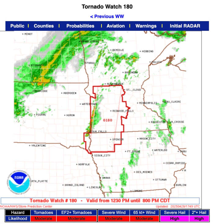
12:50 p.m. – Tornado watch issued in Minnesota
The first tornado watch of the day has been issued in Minnesota, covering a large swath of central, west-central, and southwestern Minnesota.
The watch went into effect at 12:30 p.m. and will remain in effect until 8 p.m.
The watch covers the following counties: Brown, Chippewa, Cottonwood, Jackson, Kandiyohi, Lac Qui Parle, Lincoln, Lyon, Martin, McLeod, Meeker, Murray, Nicollet, Nobles, Pipestone, Pope, Redwood, Renville, Rock, Sibley, Stearns, Stevens, Swift, Watonwan and Yellow Medicine.
NWS SPC
12:30 p.m. – Minneapolis Public Schools cancels after-school activities
Minneapolis Public Schools has followed the city’s lead in closing early, canceling after-school activities.
“Caregivers, students will be sent home on their regular bus or please make arrangements to pick up students immediately after school. Buildings and Minneapolis Kids will remain open until all students are picked up,” the note to parents reads.
12:20 p.m. – Latest from the Storm Prediction Center
The Twin Cities continues to be in the highest-risk zone for strong tornadoes late Monday afternoon into the evening.
Large hail in excess of 2 inches in diameter is also a significant threat.
The City of Minneapolis says it is closing its public-facing offices on Monday afternoon in anticipation of Monday’s severe weather.
“The National Weather Service predicts the risk of severe storms in Minneapolis to be unusually high – a level 4 of 5 – with tornadoes, large hail, damaging winds, and frequent lightning likely,” the city said.
The city’s non-emergency facilities, including its Service Center, will close at 2 p.m. Meanwhile its 311 call center has had its hours extended to 9 p.m. “to take storm-related calls.”
Residents are advised to ensure they have multiple ways to receive alerts, and be prepared to take shelter in a basement or interior room.
“The most dangerous period is likely during the late afternoon and evening when strong tornado potential should be maximized. Scattered large to very large hail and damaging winds are likely as well,” says the 11:30 a.m. update from the SPC.
“Storms will be most numerous over central MN, with increasingly sparse development with southward extent across IA. Supercells capable of strong tornadoes and very large hail appear likely. Storms will track into western WI during the evening with a continued risk of significant severe weather.”
11:04 a.m. — ‘Big time significant’ tornado threat in Minnesota, Iowa
10:50 a.m. — Watch possibly coming in southwestern MN
This from the Storm Prediction Center: “Isolated convection may develop over the next couple of hours from far eastern South Dakota into southwest Minnesota, northwest Iowa, and possibly northeast Nebraska. Large hail and damaging gusts would be initial risk, though a tornado risk also could increase with time/eastern extent. Area is being monitored for possible watch issuance.”
SPC
10 a.m. — NWS Twin Cities maintaining forecast
9:45 a.m. — HRRR vs. NAM3km simulated radar
The 9 a.m. update from the HRRR model shows storms redeveloping in south-central Minnesota around 3-4 p.m., with those storms advancing to the east and impacting the Twin Cities, Mankato and Rochester during the early evening hours.
WeatherBell
The latest NAM3km model, however, doesn’t show the squall line developing mid-afternoon. It appears to try and develop cells in south-central Minnesota, but instead waits until some supercells fire in southwestern Minnesota between 5-7 p.m.
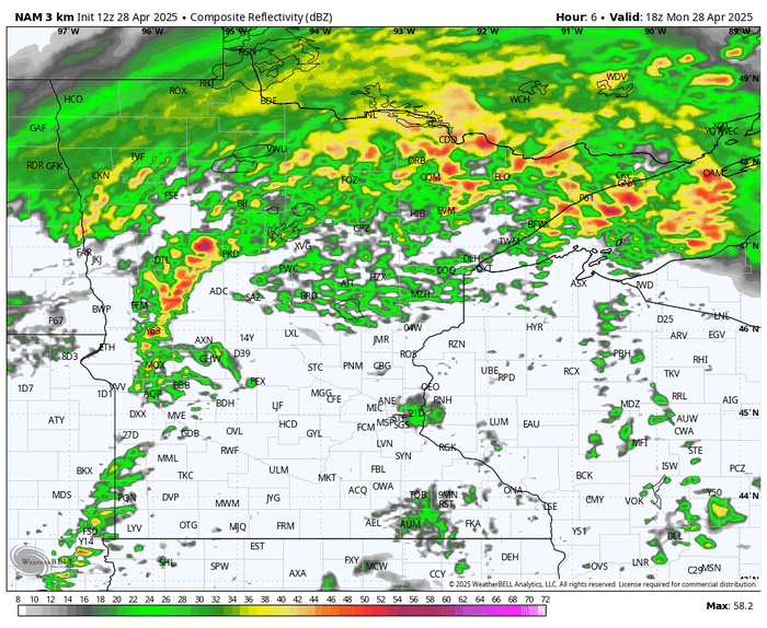
WeatherBell
9 a.m. — Moderate risk, level 4 of 5 on the severe scale
The Storm Prediction has placed a moderate risk — level 4 of 5 on the severe scale — over the Twin Cities, Mankato and Rochester. In the images below, you’ll see the severe weather outlook, both zoom out on the region and zoomed in on Minnesota, along with the tornado and hail threat zones.
NWS Twin Cities
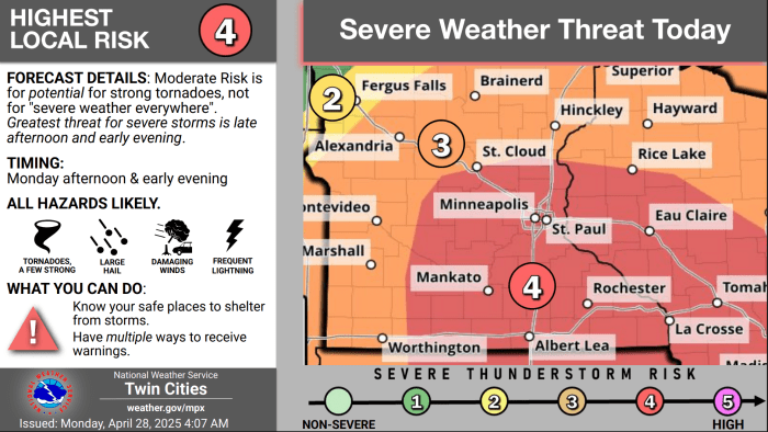
NWS Twin Cities
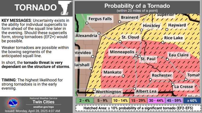
NWS Twin Cities
NWS Twin Cities