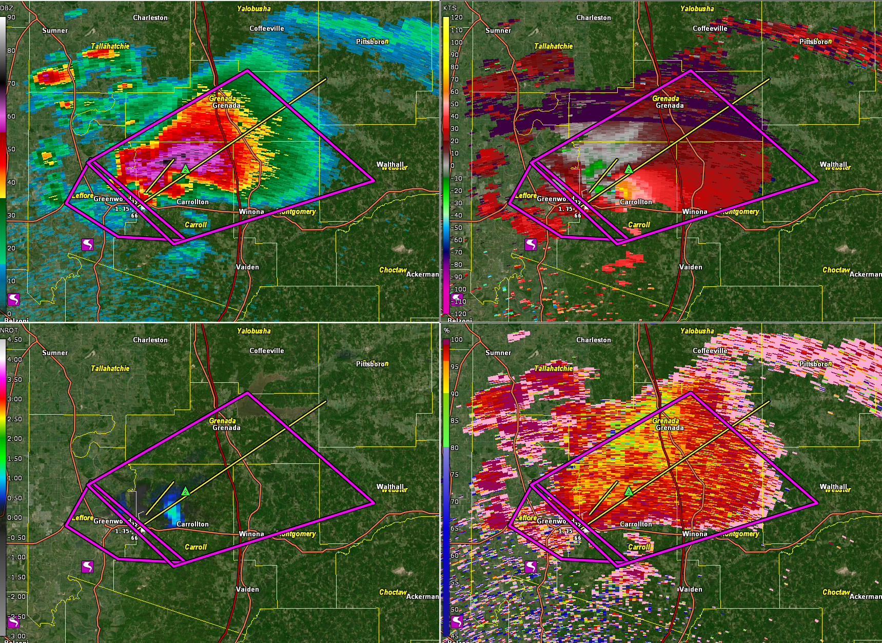
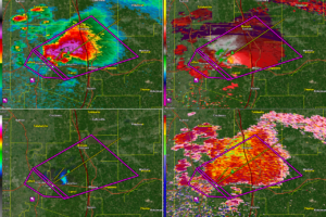
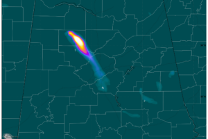
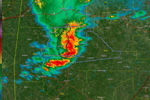
A very dangerous storm is ongoing early this morning across the Mississippi Delta just to the east of Greenwood, MS.
A wedge tornado is reported on the ground with the isolated supercell.
It is in Carroll county just north of Carrollton and will be passing over I-55 north of Winona.
It is moving in the general direction of Tupelo. The environment will become slightly less unstable the further northeast it goes, but the shear will remain just as strong so there is no sign the storm will weaken.

This same storm produced a confirmed tornado north of Belzoni in Humphreys County. A storm chaser reported a tornado near Phillipeton in southern Leflore County around 11:42 p.m.
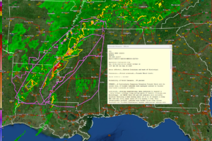
117 WFUS54 KJAN 150458 TORJAN MSC015-043-083-097-155-150600-
/O.NEW.KJAN.TO.W.0038.250315T0458Z-250315T0600Z/
BULLETIN – EAS ACTIVATION REQUESTED Tornado Warning National Weather Service Jackson MS

1158 PM CDT Fri Mar 14 2025
The National Weather Service in Jackson has issued a
* Tornado Warning for… Northwestern Carroll County in north central Mississippi… Southeastern Grenada County in north central Mississippi… East central Leflore County in north central Mississippi… West central Webster County in north central Mississippi…
Northwestern Montgomery County in north central Mississippi…

* Until 100 AM CDT.
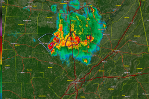
* At 1158 PM CDT, a confirmed tornado was located near Greenwood,
moving northeast at 40 mph.
HAZARD…Damaging tornado and ping pong ball size hail.
SOURCE…Weather spotters confirmed tornado.
IMPACT…Flying debris will be dangerous to those caught without shelter. Mobile homes will be damaged or destroyed. Damage to roofs, windows, and vehicles will occur. Tree
damage is likely.
* The tornado will be near… Malmaison, North Carrollton, Carrollton, and Teoc around 1205 AM CDT. Jefferson around 1210 AM CDT. Grenada and Elliott around 1220 AM CDT. Duck Hill around 1225 AM CDT.
Gore Springs and Misterton around 1235 AM CDT.
PRECAUTIONARY/PREPAREDNESS ACTIONS…
To repeat, a tornado is on the ground. TAKE COVER NOW! Move to a basement or an interior room on the lowest floor of a sturdy building. Avoid windows. If you are outdoors, in a mobile home, or in a vehicle, move to the closest substantial shelter and protect
yourself from flying debris.
&&
LAT…LON 3357 8933 3340 8998 3362 9026 3387 8974
TIME…MOT…LOC 0458Z 236DEG 36KT 3350 9010
TORNADO…OBSERVED
MAX HAIL SIZE…1.50 IN
$$
86
Category: Alabama’s Weather, ALL POSTS, Severe Weather, Social Media
Page 2
 A significant tornado outbreak is expected across Alabama this afternoon and evening, with the potential for long-track tornadoes, damaging winds over 70 mph, and large hail as storms rapidly develop and move eastward.
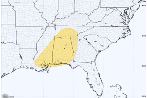
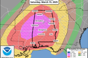 A dangerous tornado outbreak is expected across northern and central Alabama this afternoon and evening, with numerous strong to violent, long-track tornadoes, damaging winds, and large hail posing a significant threat.
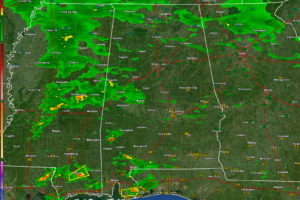
 Storms will start moving into Northwest and West Central Alabama after 2:30 a.m. They could be severe and may even produce tornadoes.
 It is moving in the general direction of Tupelo. The environment will become slightly less unstable the further northeast it goes, but the shear will remain just as strong so there is no sign the storm will weaken.
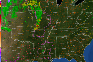 A dangerous tornado outbreak is expected, with long-track, violent tornadoes, destructive winds, and large hail posing a significant threat across Alabama and the Deep South.
 The second round of storms arrives Friday night with the potential for severe weather, including damaging winds and large hail, and the main event unfolds Saturday with a significant outbreak expected across Alabama and Mississippi, featuring supercells capable of producing strong tornadoes, destructive winds, and large hail.
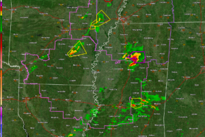
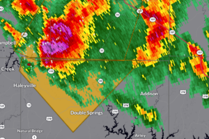
 The storms over North Central Alabama have weakened in the past hour and no warnings are in effect. The strongest storm is over Winston County and will push into northern Walker and eventually southern Cullman, Blount, and northern Jefferson counties.
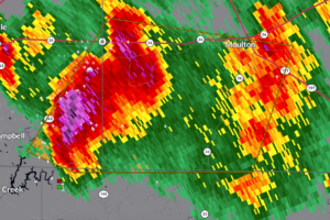
 Severe thunderstorms in northwestern Winston County are producing 60 mph wind gusts, quarter-size hail, and dangerous lightning—seek shelter indoors immediately.
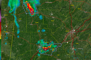
 Severe thunderstorms moving east through southeastern Franklin and southwestern Lawrence counties may produce 60 mph winds, quarter-size hail, and frequent lightning—seek shelter indoors immediately.
 Strong storms are already forming over West Alabama this morning.
 Smoke from a prescribed burn in Winston County has drifted into the Birmingham area, prompting a Code Red Air Quality Alert for Jefferson and Shelby Counties on Tuesday.. Air quality is not good tonight either.
 No severe storms are expected across Central Alabama this afternoon, but we are monitoring a severe weather threat that is firming up for Saturday.
 Today will bring rain and cooler temperatures as spring approaches, with fluctuating conditions, midweek showers, and a gradual warming trend into next week.
 There are a couple of storms over South Central Alabama tonight with gusty winds and lightning, but there won’t be severe. Closer to the coast, there could be some severe weather overnight.
