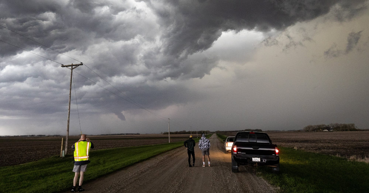
After one round of thunderstorms moved across Minnesota on Monday morning, a second, stronger round of storms brought hail, high winds, heavy rain, funnel clouds and reports of at least one tornado during the afternoon and evening hours.
As of 6 p.m., there had been reports of severe weather north and south of the Twin Cities, and storms continued to move through those areas — but the metro area appeared to have escaped the strongest storms.
The risk of severe storms had prompted actions usually seen for winter storms in Minnesota. Some cities canceled afternoon and evening meetings, and some school districts announced they were ending classes early and canceling after-school activities to allow students and staff to make it home before the severe weather hit.
7:15 p.m.: Reports of storm damage in Kenyon area
The National Weather Service received reports of some damage to buildings in the Kenyon area in the wake of Monday evening’s severe storms.

MPR News helps you turn down the noise and build shared understanding. Turn up your support for this public resource and keep trusted journalism accessible to all.
A barn and silos were reported destroyed, and a semi tipped over, just before 6 p.m. about 6 miles west of Kenyon.
And as the storms moved through the city of Kenyon around 6 p.m., emergency management officials reported roof damage to a large commercial warehouse.
The storms also continued to produce large hail across southern Minnesota, with reports of quarter-size hail at Kasson and Mazeppa, and half-dollar-size hail at Alden and Frost between about 6 and 7 p.m.

6:35 p.m.: More reports of large hail in southern Minnesota
Severe storms have continued to produce large hail in southern Minnesota as they move east on Monday evening.
The National Weather Service received a report of hailstones the size of golf balls northeast of Hope, near Interstate 35 south of Owatonna, at 6:15 p.m.
At about the same time, quarter-size hail was reported in Owatonna.
There have also been reports of damaging winds, with a weather spotter reporting a large pine tree knocked down by storms in Minnesota Lake just after 5:30 p.m.


A squall line sweeps over farm fields near Minnesota Lake in Faribault County, Minn., on Monday.
Ben Hovland | MPR News
6:27 p.m.: Tornado warning for Albert Lea, Alden, Clarks Grove, Glenville, Kiester
The National Weather Service has issued a tornado warning for southeastern Faribault and western Freeborn counties until 7 p.m.
The Weather Service reported at 6:24 p.m. that radar indicated rotation in a storm near Mansfield, moving northeast at 40 mph. The storm may also produce large hail.
6 p.m.: Tornado warning for Kenyon, Pine Island, Zumbrota, Goodhue, Wanamingo
The National Weather Service has issued a tornado warning for southeastern Rice, northeastern Steele and southwestern Goodhue counties until 6:30 p.m.
The Weather Service reported at 5:56 p.m. that radar indicated rotation in a storm near Kenyon, moving east at 55 mph.
5:50 p.m.: Tornado warning for Faribault, Kenyon, Nerstrand
The National Weather Service has issued a tornado warning for southeastern Rice and southwestern Goodhue counties until 6:15 p.m.
The Weather Service reported at 5:44 p.m. that radar indicated rotation in a storm near Faribault, moving northeast at 45 mph. Quarter-size hail also is possible from that storm cell.
5:45 p.m.: Tornado warning for Owatonna, Medford, Clinton Falls
The National Weather Service has issued a tornado warning for northern Steele County until 6 p.m.
The Weather Service reported at 5:40 p.m. that radar indicated rotation in a storm near Owatonna, moving east at 60 mph. Large hail also is possible.

Drivers gather underneath a freeway overpass for shelter from heavy rain and hail along Interstate 90 near Wells, Minn., just after 6:30 p.m. on Monday, as a severe storm moves through the area.
Minnesota Department of Transportation
Utility crews are responding to scattered power outages across Minnesota in the wake of Monday’s storms.
As of 5:30 p.m., the largest single outage was in northern Minnesota, where Minnesota Power was reporting about 2,800 customers without electricity northeast of Grand Rapids — including Bovey, Coleraine, Marble and Taconite.
That part of the state was not the focus for Monday’s severe weather, but still saw thunderstorms roll through during the afternoon.
Elsewhere in Minnesota, Xcel Energy was reporting multiple outages affecting more than 3,600 customers, mostly in the Twin Cities, as of 5:30 p.m. There hadn’t yet been any widespread storms in the metro area, so those outages may have not been related to weather.
5:27 p.m.: Tornado warning for Faribault, Waseca, Janesville, Morristown, Waterville
The National Weather Service has issued a tornado warning for southeastern Le Sueur, southwestern Rice, northwestern Steele and northern Waseca counties until 5:45 p.m.
The Weather Service reported at 5:20 p.m. that radar indicated rotation in a storm 5 miles northwest of Waseca, moving northeast at 60 mph. Large hail also is possible.
5:07 p.m.: Tornado warning for Mapleton, Winnebago, St. Clair, Minnesota Lake
The National Weather Service has issued a tornado warning for southeastern Blue Earth, northwestern Faribault and southwestern Waseca counties until 5:45 p.m.
The Weather Service reported just after 5 p.m. that it had received multiple tornado reports in the Winnebago area, and that there might be two tornadoes on the ground as the storm moved northeast at 60 mph. Large hail also is possible.
The Weather Service later said the reported sighting may have been “a gustnado, which is more of a broad area of rotation near the ground and no clear attachment to the storm cloud base.”

Storm clouds are pictured near Vernon Center, Minn., as severe thunderstorms move across Minnesota on Monday.
Ben Hovland | MPR News
4:58 p.m.: More reports of hail across southern, central Minnesota; tornado sighting in Martin County
The National Weather Service is receiving more reports of large hail as severe storms continue to march across parts of southern and central Minnesota on Monday afternoon:
- penny-size hail at St. James in Watonwan County at 4 p.m.
- quarter-size hail south of St. Cloud just after 4 p.m.
- penny-size hail at Nicollet in Nicollet County at 4:20 p.m.
- quarter-size hail near St. Peter in Nicollet County at 4:30 p.m.
- ping-pong-ball-size near Santiago in Sherburne County at 4:38 p.m.
The National Weather Service also said spotters reported a tornado near Ceylon, close to the Iowa border in Martin County, at 4:24 p.m. That prompted a tornado warning for parts of Martin, Faribault and Blue Earth counties until 5 p.m.; there were no immediate reports of damage.
4:43 p.m.: Tornado warning near Princeton
A severe thunderstorm capable of producing a tornado was 7 miles west of Princeton, or 22 miles east of St. Cloud, moving northeast at 45 mph. Southeastern Benton County, north central Sherburne County, west central Isanti Count, and south central Mille Lacs County is under tornado warning until 5:15 p.m.
4:24 p.m.: Tornado reported near Ceylon
The National Weather Service said weather spotters reported a tornado near Ceylon, about 8 miles southwest of Fairmont in south central Minnesota, moving northeast at 60 mph at 4:24 p.m. People in southwestern Blue Earth County, northwestern Faribault County and central Martin County should take cover until 5 p.m.
4:18 p.m.: Tornado warning includes St. Cloud
A warning was issued for a possible tornado until 4:45 p.m. in southeastern Benton County, northwestern Sherburne County, southeastern Stearns County and north central Wright County in central Minnesota. At 4:14 p.m., “a severe thunderstorm capable of producing a tornado was located near Clearwater, or 10 miles south of St. Cloud, moving northeast at 45 mph,” the National Weather Service reported.
No funnel cloud or tornado had been reported in the area as of 4:21 p.m.
4:15 p.m.: Additional reports of hail, strong winds in southern Minnesota
Severe storms continue to drop large hail as they roll across southern Minnesota on Monday afternoon.
The National Weather Service office in Sioux Falls, S.D., received a report of nickel- to quarter-size hail covering the ground in Jackson County, northeast of Round Lake, just after 3:15 p.m.
At about the same time, emergency management officials reported quarter-size hail in Windom, in Cottonwood County.
The storms have also produced strong winds, with a gust of 60 mph reported northwest of Jackson just after 3:30 p.m.
3:39 p.m.: Tornado warning in central Minnesota
A tornado warning has been issued until 4:15 p.m. for northeastern Meeker County, southeastern Stearns County and northwestern Wright County in central Minnesota, including St. Cloud.

Mammatus clouds over southwest Rochester on Monday.
Catharine Richert | MPR News
3:28 p.m.: New tornado watch includes Twin Cities
The National Weather Service issued a tornado watch until 11 p.m. for a swath of central and southeast Minnesota including the Twin Cities metro, St. Cloud and Rochester. The main concern is “very large hail and a few tornadoes,” but strong tornadoes are possible.
3:25 p.m.: Severe storms dropping large hail in parts of southern Minnesota
The severe storms moving across southern Minnesota on Monday afternoon have produced hailstones the size of baseballs.
The National Weather Service office in Sioux Falls, S.D., received a report of baseball-size hail near Beaver Creek in far southwest Minnesota as storms moved through at about 1:30 p.m.
Spotters reported quarter-size hail in Cottonwood County, northeast of Dundee, just before 3 p.m., and in Jackson County, southeast of Brewster, just after 3 p.m.
The storms prompted a tornado warning for parts of Cottonwood and Murray counties just after 2:30 p.m., but there were no immediate confirmed sightings of a tornado or reports of damage.
3:15 p.m.: Severe thunderstorm warning for southwest Minnesota
The National Weather Service issued a severe thunderstorm warning for a storm near Comfrey about 30 miles southwest of New Ulm, moving northeast at 60 mph. The storm could produce hail the size of a half-dollar coin.
There also is a severe thunderstorm warning for a storm about 11 miles east of Worthington, moving northeast at 45 mph, that might produce hail the size of a ping-pong ball.
Meanwhile, severe thunderstorms were moving into Brainerd and were expected to bring pea-sized hail until about 4 p.m.
2:35 p.m.: Tornado warning in southwest Minnesota
The National Weather Service issued a tornado warning that includes Jeffers and Storden in southwest Minnesota until 3 p.m. It also said there is possibly very large hail headed toward Dundee, Minn.. It advises anyone within the warning zone to seek shelter.

Storm clouds swirl above Interstate 90 near Rushmore in southwest Minnesota on Monday.
Courtesy of the Minnesota Department of Transportation
1:30 p.m.: Schools cancel after-school activities
Many school districts are canceling after-school activities, including extended learning, athletics and facility rentals. School districts that have announced closures include Minneapolis Public Schools, Roseville Area Schools, St. Louis Park Public Schools, Richfield Public Schools, Anoka-Hennepin schools, Minnetonka schools, Independent School District 728, Eastern Carver County Schools, St. Cloud schools, Rosemount-Apple Valley-Eagan ISD 196 and Osseo Area Schools.
Rochester Public Schools canceled middle school after-school activities and night school classes. All activities at Rochester school sites must conclude by 6 p.m.
Many after-school care programs will remain open until everyone has been picked up, but schools are asking parents to pick up their children as soon as possible.
12:30 p.m.: Tornado watch issued for southwest and central Minnesota
NOAA’s Storm Prediction Center has issued a tornado watch until 8 p.m. including most of southwest and central Minnesota. Storms within the watch zone may produce large hail, damaging winds, and possible tornadoes into Monday evening.
11:53 a.m.: School districts closing early
At least five school districts — Blue Earth Area, Jackson County Central, Martin County West, Red Rock Central and Windom — announced they were ending classes early Monday because of the risk of severe weather.
“We want everyone home safely before the storms begin,” Martin County West school officials wrote.
“With nearly 800 students relying on bus transportation — some on routes that require up to two hours from time of departure to return to bus garages — we want to ensure everyone arrives home safely before the potential for severe weather increases,” Blue Earth Area school officials wrote.
St. Paul Public Schools preemptively canceled most after-school programs and activities for Monday afternoon and evening due to the risk of severe storms.
11:41 a.m.: Preparations begin for coming storms
The city of Minneapolis said it would close public-facing, nonemergency city facilities and services at 2 p.m. Its 311 call center will have extended hours — until 9 p.m. — to handle any storm-related public service calls.
The city said it had activated its Emergency Operations Center and was conducting outreach to homeless shelters and service providers to ensure unhoused residents have a safe place to go.
Utilities across the region were also closely monitoring weather conditions for potential severe storms that could down trees and power lines. Xcel Energy said it’s “tracking these forecasts and will stage additional crews as needed to respond to any outages, attending to the largest outages first to quickly get the most customers back online as soon as possible.”

Severe weather threat for Monday
National Weather Service