The Twin Cities and much of Minnesota dodged a moderate risk weather bullet Monday.
Severe storms hit parts of Minnesota but left other areas with little weather to write home about.
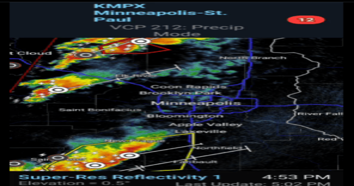
Tornado watches covered much of Minnesota as expected Monday.
Numerous severe thunderstorms and tornado warnings were issued Monday. Some of the strongest cells blew through areas south of the Twin Cities along I-35.

MPR News helps you turn down the noise and build shared understanding. Turn up your support for this public resource and keep trusted journalism accessible to all.
But as of this post only 1 confirmed tornado touchdown occurred in Minnesota
- MPX issues Tornado Warning [tornado: OBSERVED, hail: 1.00 IN] for Blue Earth, Faribault, Martin [MN] till 5:00 PM CDT * At 424 PM CDT, a confirmed tornado was located near Ceylon, or 8 miles southwest of Fairmont, moving northeast at 60 mph.
There were many reports of severe hail across Minnesota and a funnel cloud. Here are some select severe weather reports.
- At 1:27 PM CDT, 2 ENE Beaver Creek [Rock Co, MN] Public reports Hail of baseball size (M2.75 Inch). Non-uniform hail measured at 2.8 inches at its widest.
- 4 ENE Round Lake [Jackson Co, MN] Public reports Hail of quarter size (M1.00 Inch) at 3:18 PM CDT — ground covered in nickel to quarter size hail.
- 5 NW Jackson [Jackson Co, MN] Public reports Tstm Wnd Gst of M60 MPH at 3:33 PM CDT —
- 1 NNE St. Peter [Nicollet Co, MN] Public reports Hail of quarter size (M1.00 Inch) at 4:30 PM CDT — Picture via X.
- 3 SE Luxemburg [Stearns Co, MN] Trained Spotter reports Hail of quarter size (M1.00 Inch) at 4:06 PM CDT — Time estimated via radar. Photo measurement provided.
- Santiago [Sherburne Co, MN] Trained Spotter reports Hail of ping pong ball size (M1.50 Inch) at 4:38 PM CDT — Time estimated via radar.
- 1 NW Princeton [Mille Lacs Co, MN] Trained Spotter reports Funnel Cloud at 4:48 PM CDT — Funnel cloud reported west of Hwy 169 and Hwy 95 just west of Princeton. Time estimated via radar.
- 6 NE Frost [Faribault Co, MN] Public reports Hail of half dollar size (M1.25 Inch) at 5:54 PM CDT
- 2 NNE Hope [Steele Co, MN] Storm Chaser reports Hail of golf ball size (M1.75 Inch) at 6:10 PM CDT — Measurement provided via phone.
- Owatonna [Steele Co, MN] Public reports Hail of quarter size (M1.00 Inch) at 6:13 PM CDT — Measurement provided via phone.
- 3 NW Cohasset [Itasca Co, MN] Public reports Rain of 2.25 Inch at 4:02 PM CDT —
- Minnesota Lake [Faribault Co, MN] Amateur Radio reports Tstm Wnd Dmg at 5:34 PM CDT — Amateur Radio operator provided photo of large pine tree blown over.
- 6 W Kenyon [Rice Co, MN] Amateur Radio reports Tstm Wnd Dmg at 5:50 PM CDT — Barn destroyed, silos destroyed, semi tipped over. Time estimated via radar.
The Twin Cities escaped the storm lines to the north and south. Quite the disappearing act.

Our weather quiets down considerably the rest of this week. Highs will warm through the 60s and into the 70s by the upcoming weekend.

Forecast high temperatures Saturday.
NOAA