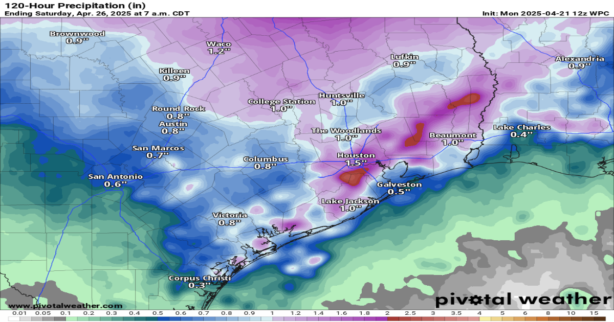
Cumulative rainfall totals through Saturday morning, according to the National Weather Service’s Weather Prediction Center, could be as high as an inch to 2 inches this week, with more rain in areas that are repeatedly hit by daily storms.
Weather Prediction Center / Pivotal Weather
After heavy rainfall prompted high-water rescues and flash flood warnings in parts of the Houston metro area on Monday, more downpours are on the way Tuesday.
The risk of minor street flooding will linger through the coming days as scattered storms become more frequent by the middle of the week. Here’s what we know about the flood risk Tuesday — and what caused those bizarre cloud formations that were spotted over Southeast Texas on Monday.

A slow-moving frontal boundary brought storms Monday into Southeast Texas — but we’re not referring to it as a cold front is because the air behind it lacked a clear difference in temperatures or humidity-linked dew points. It did, however, serve as a focal point for storms to develop.
Article continues below this ad
The boundary had shifted offshore of the upper Texas Gulf Coast on Monday night, but it is poised to push back into the Houston metro area Tuesday. Coupled with an upper-level atmospheric disturbance called a shortwave, the frontal boundary will have the necessary support for the redevelopment of scattered storms.
Tuesday morning should provide an easier commute than Monday morning, with most of us starting rain-free with temperatures around 70 degrees. Some pockets of dense fog are likely, especially in areas that got soaked with rain Monday.

Wednesday provides even more downpours as another short wave of low atmospheric pressure crosses over our heads. Forecast modeling indicates this upper-level disturbance could be more vigorous than Tuesday’s disturbance, resulting in an increase in downpours and storm chances.
This future weather radar image depicts numerous thunderstorms early Wednesday afternoon, according to the European forecast model.
Pivotal Weather
Rain chances Wednesday across Southeast Texas will be closer to 80% as opposed to Tuesday’s roughly 60% chance. This doesn’t mean Wednesday will see rain from start to finish, but it does mean you’ll want to have the umbrella with you and prepare for slower morning and evening commutes.

Article continues below this ad
Cumulative rainfall totals through Wednesday should generally range from an inch to 2 inches. However, some storms could generate enough rain to prompt the National Weather Service to issue flood warnings.
Indications point toward a drier second half of the week across Southeast Texas. Daily storm chances will decrease, with rain becoming more hit-or-miss.
Rain chances Thursday and Friday fall back to around 40%, with favored rainy spots expected north of Interstate 10. Rainfall totals Thursday and Friday should remain below an inch in most areas, with spots that repeatedly get storms seeing more than an inch.
Article continues below this ad
As a ridge of high atmospheric pressure sets up shop overhead, warmer weather would be likely, with peak daytime temperatures inching toward 90 degrees. Between now and then, afternoon temperatures should top out in the lower to mid-80s.
After storms rolled through the Houston metro area Monday, you might have seen strange, pouch-like cloud formations. Those were mammatus clouds. These sac-like cloud shapes, whose name comes from the Latin word for “udder,” form when moisture-laden air descends into a drier environment. Their rounded lobes vary in size and are smooth in appearance.
Dan Reilly, a former meteorologist at the regional National Weather Service office for Houston and Galveston, captured these photos of mammatus clouds over League City after storms passed Monday.
Dan Reilly / Facebook
Mammatus clouds, linked to Monday’s strong storms, are dramatic signs of atmospheric turbulence. Because mammatus clouds form on the underside of a cumulonimbus anvil, they are only seen from the ground and not from space.
Article continues below this ad