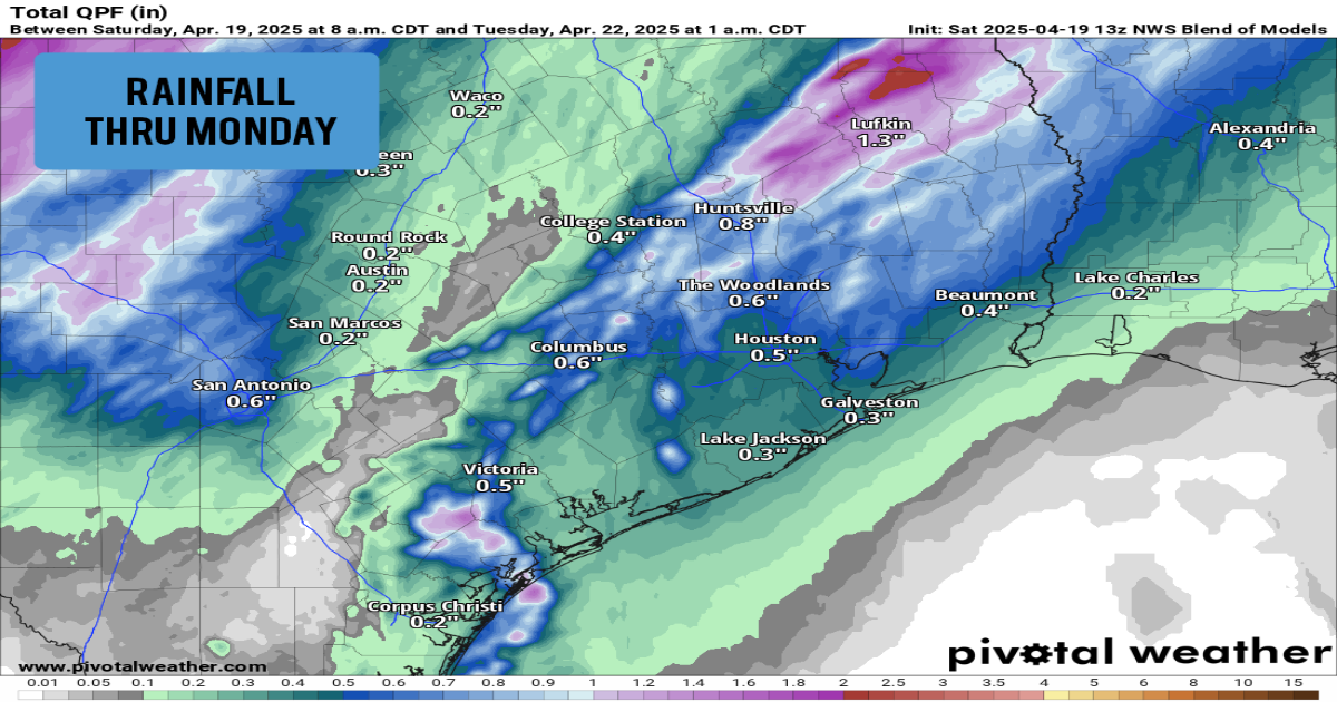
Shown are the expected rain totals across Southeast Texas through Monday, according to the National Blend of Models.
Pivotal Weather
Houston has not received any measurable rain over the past 14 days — a rare occurrence here in the middle of spring. However, as a springtime cold front approaches from the west Sunday evening, chances of showers and storms will increase across the Houston area.
Don’t worry. If you have any outdoor Easter plans, all hope is not lost. Rain chances through the first half of the day Sunday will actually be quite low. The higher chance of rain will arrive Sunday evening and into the overnight hours. Here’s a timeline of what you can expect.

Morning (6 a.m.-noon): With the cold front more than 100 miles west of Houston, Sunday morning is expected to be relatively quiet across Southeast Texas. Conditions will be warm and muggy, as morning low temps will only drop into the low to mid-70s. Temperatures will rise into the low 80s by 11 a.m.
Article continues below this ad
There is a chance of a few isolated showers through the morning, but overall rain chances are expected to be at 20% or less. If you have any outdoor plans, it won’t be a bad idea to take an umbrella just in case, but there’s a good chance you won’t need it.
Shown is the future radar at noon Sunday (left) as well as 9 p.m. Sunday (right). Rain chances will pick up Sunday evening and overnight,

Pivotal Weather
Afternoon (noon-6 p.m.): Rain chances will start to increase slightly through the afternoon and early evening. Still, rain will be scattered, with only a 30-40% chance of storms across the Houston metro area. The greater chances of rain will stay north and west of Houston. Temperatures will be warm, with highs rising into the mid-80s.
Evening and overnight (6 p.m.-6 a.m.): This is when Houston rain chances will be at their greatest, especially during the overnight hours as the cold front moves through the area. A few isolated storms could produce quarter-sized hail and damaging wind gusts. However, most storms will stay below severe weather thresholds.
A few lingering showers and storms will remain possible through Monday afternoon, but rain chances will end by the early evening.

Article continues below this ad
Rain totals are expected to stay relatively low. Models indicate that the Houston metro area will see close to a half-inch of rain through Monday. Totals will be higher as you move north, with between 0.75 and 1.5 inches likely from Huntsville to Lufkin.
A relatively active weather pattern is expected to continue for much of next week. From Tuesday through Friday, Houston will see 30-60% rain chances each day. The atmosphere will stay relatively unstable as well, leading to at least an isolated threat of large hail and damaging winds. Stay tuned to houstonchronicle.com/weather for details on the timing and intensity of these thunderstorms.
Temperatures will stay consistently warm throughout the week. Houston can expect high temperatures in the low to mid-80s each day, while morning low temps hover in the low 70s.
Article continues below this ad