HOUSTON – We continue to track the low-pressure system, centered over the Red River, that is slowly moving to the east. Severe thunderstorms have been sparking out ahead of the associated cold front out to our north and west near places like Dallas, Abilene, and San Angelo.
This system will eventually head our way and bring some messy weather with it for your Easter Sunday.
Rain chances stick around throughout the day Sunday (Copyright 2025 by KPRC Click2Houston – All rights reserved.)
You can track radar here:

Will it rain on Easter?
We continue to track the slow-moving cold front. Out ahead of the front, warm and humid air continues to be our main focus with the possibility of storms and behind the front, cooler air sinks in. This is why we are expected to have thunderstorms tomorrow. When both air masses collide, we have the chance for rain, thunderstorms, and gusty conditions, bringing us a low risk for severe weather on Sunday. The main threats we are watching for include wind and hail.
Severe Risk (Copyright 2025 by KPRC Click2Houston – All rights reserved.)
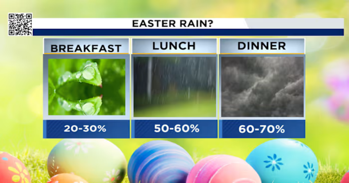
Hour by Hour Forecast:
Rain is possible from mid-morning into the evening (Copyright 2025 by KPRC Click2Houston – All rights reserved.)
- Breakfast time (7:00 AM – 9:00 AM): We’re tracking a muggy morning with cloudy skies, followed by the chance for rain and drizzle as we get closer to the mid-morning hours.
- Brunch time (10:00 AM – 11:00 AM): Rain starts to taper off some on the back half of the mid-morning timeframe and we start to get some drying nearing the afternoon.
- Lunch time (12:00 PM – 2:00 PM): Isolated thunderstorms are possible along the coastline, while most of us see just cloudy conditions.
- Mid-afternoon (3:00 PM – 4:00 PM): Rounds of thunderstorms fire up ahead of the cold front; some could be strong-to-severe and produce frequent lightning.
- Dinner time (6:00 PM – 8:00 PM): We’re tracking the chance for heavier rain, rowdy thunderstorms and gustier conditions, making indoor Easter activities your best bet.
Rain Totals: With the newest model data, we’re seeing rain totals increase with the chance of more storm activity for Easter Sunday. Locally higher totals are possible with the heaviest storms. Anywhere from 0.05 inches to nearly 3 inches of rainfall is possible.

By Monday morning, upwards to 3 inches of rainfall are possible, especially with the heavier storms (Copyright 2025 by KPRC Click2Houston – All rights reserved.)
Your KPRC 2 weather team will keep you updated Sunday with the latest.