Severe weather is expected to hit Oklahoma overnight, bringing a risk of large hail, damaging winds and a flooding threat due to heavy rainfall.>> Download the KOCO 5 App | Subscribe to KOCO 5’s YouTube channelBelow are live updates from the storm threat. Follow along throughout the night for more information. 11:04 p.m. Saturday Update: A tornado warning was issued for Hughes County for a storm located near Wetumka, moving northeast at 25 mph.10:56 p.m. Saturday Update: First responders are searching for passengers after two vehicles were swept off the road in southeast Moore.The Moore Police Department confirmed on the scene near Southeast 12th Street and S Eastern Avenue that two vehicles went off the road.One of those vehicles was a truck. The driver of the truck and his son were able to escape, according to police. The second vehicle was a Jeep. That Jeep was washed into a creek and wedged against a drainage ditch. One person who was inside that Jeep was accounted for. Two people were not located as of about 10:45 p.m. 10:46 p.m. Saturday Update: A tornado warning was issued for Hughes County for a storm located near Yeager, moving northeast at 25 mph.Another tornado warning was issued for Bryan and Marshall counties until 11:15 p.m.10:39 p.m. Saturday Update: Residents in Holdenville should take shelter immediately. A tornado located just south of town is moving into the city. 10:26 p.m. Saturday Update: KOCO 5 Field Meteorologist Michael Armstrong showed the truck almost completely underwater near SW 4th Street and Interstate 35. The truck was later able to be removed from the drainage ditch. Michael reports that the Moore Fire Department confirmed that the driver of the vehicle was able to get out of the vehicle and make it home.The Moore Police Department is responding to more than a dozen motorist assists. They said the area near the OnCue has been a problem area, as well as areas near Broadway and SW 19th Street, and Southeast 12th Street and South Eastern Avenue. Moore police confirmed that Norman Fire Department and Oklahoma City Fire Department were called to assist with calls, including at Southeast 12th Street and South Eastern Avenue. 10:20 p.m. Saturday Update: A tornado warning was issued for Hughes, Pontotoc and Seminole counties until 11 p.m. The storm was located near Francis, moving northeast at 30 mph.10:17 p.m. Saturday Update: A tornado warning was issued for a storm in Pontotoc County. A confirmed tornado was located near Francis, moving northeast at 20 mph.10:05 p.m. Saturday Update: A tornado warning was issued for Pontotoc and Seminole counties for a storm located over Ada, moving northeast at 20 mph. Anyone in Ada should be in their shelter. Damon is live on Facebook.10:01 p.m. Saturday Update: A tornado warning was issued for Pontotoc County for a storm located 4 miles north of Fitzhugh, moving northeast at 20 mph. Damon is live on Facebook.9:57 p.m. Saturday Update: KOCO 5 Field Meteorologist Michael Armstrong is on the scene of a flooded vehicle on at OnCue near SW 4th Street and Interstate 35 in Moore. 9:48 p.m. Saturday Update: A tornado warning was issued for Pontotoc County until 10:30 p.m. A severe thunderstorm capable of producing a tornado was located near Fitzhugh, moving northeast at 15 mph. Damon is live on Facebook.9:45 p.m. Saturday Update: A tornado warning was issued for Love County until 10:15 p.m. The storm was located 6 miles south of Burneyville, moving northeast at 35 mph, according to the National Weather Service. 9:40 p.m. Saturday Update: Moore police have responded to more than a dozen motorists assists due to flooding. Drivers are encouraged to stay off of the roads. Heavy flooding is scene between Broadway and Tower Drive. There is also heavy flooding in neighborhoods, according to Moore police. 9:32 p.m. Saturday Update: A tornado warning was issued for Carter, Johnston and Murray counties until 10:15 p.m. The warning was issued as a severe thunderstorm capable of producing a tornado is located near Ardmore. Damon is live on Facebook. 9:22 p.m. Saturday Update: A tornado warning has been issued for Garvin, Murray and Pontotoc counties until 10 p.m. The storm was located near Sulphur, moving northeast at 15 mph. Damon is live on Facebook. A tornado watch was issued for Cleveland, Garvin, McClain, Pottawatomie and Seminole counties until midnight. 9:20 p.m. Saturday Update: Two severe thunderstorm warnings were issued for Garvin, Johnston, Murray and Pontotoc counties, and another in Carter, Jefferson and Love counties until 10 p.m. There have been reports of flooding in southwest Oklahoma City, Moore and Norman. 9:04 p.m. Saturday Update: A tornado warning was issued for Carter County on the west side of Ardmore, headed east. The tornado warning was issued until 9:45 p.m. 9:01 p.m. Saturday Update: A severe thunderstorm warning was issued for parts of Love and Carter counties, including Ardmore. The severe storm could bring up to 70 mph winds and golf ball-sized hail. 8:57 p.m. Saturday Update: A new tornado warning was issued for northwestern Love County and southwestern Carter County until 9:45 p.m. A confirmed tornado was located 4 miles south of Wilson, moving northeast at 20 mph, according to the National Weather Service. 8:50 p.m. Saturday Update: KOCO 5 Chief Meteorologist Damon Lane is providing an update on the storm threat live on Facebook. Click here to watch. At about 8:45 p.m., a confirmed tornado was located 7 miles north of Rubottom, moving northeast at 20 mph, according to the National Weather Service. 8:22 p.m. Saturday Update: A tornado warning has been issued for Love, Jefferson and Carter counties until 9 p.m.8:10 p.m. Saturday Update: A tornado warning has been issued for Love and Jefferson counties until 8:30 p.m. A strong thunderstorm located in northwest Oklahoma City is moving northeast at 20 mph. The storms could bring small hail, but they are not expected to be severe-warned. The tornado threat remains for southern and southeastern Oklahoma.7:50 p.m. Saturday Update: A flood warning was issued for Pottawatomie, Seminole and Atoka counties. 7 p.m. Saturday Update: A tornado watch has been issued for Atoka, Bryan, Carter, Coal, Hughes, Jefferson, Johnston, Love, Marshall, Murray, Choctaw, Pittsburg, Pushmataha and Pontotoc counties until midnight. 6:30 p.m. Saturday Update: KOCO 5 Meteorologist Sabrina Bates said the severe weather risk will continue through Saturday evening into early Sunday morning. The tornado risk is expected to stay closer to southern and southeastern Oklahoma. A line of storms from Altus to Oklahoma City to Stillwater and Tulsa will see a level one marginal risk for severe weather. Ardmore, Ada and McAlester are areas that could see a level two slight risk for severe storms. Hail could be as large as quarters, half dollars or even ping pong balls in the southern and southeastern parts of the state. But showers with embedded hail are expected across central and northern Oklahoma, moving quickly. Storms could develop in southern Oklahoma between 7 p.m. and 9 p.m. Areas from Duncan, Sulphur, Ardmore and the Red River, including parts of Texas, will see storm development.Get the latest news stories of interest by clicking here.These storms will likely start to move northeast by around 10 p.m. to 11 p.m. Heavy rain will likely continue past midnight from Stillwater, OKC, Norman, down towards Pauls Valley and over to Seminole.The rain will persist into early Sunday morning, particularly along I-35 and to the east. For those attending sunrise services on Easter, heavy rain and storms may be encountered. That rain could continue into the afternoon. Sabrina shows what to expect. Open the video player above for the timeline. Be sure to download the KOCO 5 App to receive customized weather alerts. You can watch our team coverage on the app, too.>> Check Closings>> Check Live, Interactive Radar>> Watch KOCO 5 Coverage>> Download the KOCO 5 App on iPhone>> Download the KOCO 5 App on Android>> “Like” KOCO 5 on Facebook>> “Follow” KOCO 5 on X>> Stream KOCO 5 weather updates anytime on the Very Local app
Severe weather is expected to hit Oklahoma overnight, bringing a risk of large hail, damaging winds and a flooding threat due to heavy rainfall.
>> Download the KOCO 5 App | Subscribe to KOCO 5’s YouTube channel
Below are live updates from the storm threat. Follow along throughout the night for more information.

11:04 p.m. Saturday Update: A tornado warning was issued for Hughes County for a storm located near Wetumka, moving northeast at 25 mph.
10:56 p.m. Saturday Update: First responders are searching for passengers after two vehicles were swept off the road in southeast Moore.
The Moore Police Department confirmed on the scene near Southeast 12th Street and S Eastern Avenue that two vehicles went off the road.
One of those vehicles was a truck. The driver of the truck and his son were able to escape, according to police.

The second vehicle was a Jeep. That Jeep was washed into a creek and wedged against a drainage ditch.
One person who was inside that Jeep was accounted for. Two people were not located as of about 10:45 p.m.
10:46 p.m. Saturday Update: A tornado warning was issued for Hughes County for a storm located near Yeager, moving northeast at 25 mph.
Another tornado warning was issued for Bryan and Marshall counties until 11:15 p.m.

10:39 p.m. Saturday Update: Residents in Holdenville should take shelter immediately. A tornado located just south of town is moving into the city.
10:26 p.m. Saturday Update: KOCO 5 Field Meteorologist Michael Armstrong showed the truck almost completely underwater near SW 4th Street and Interstate 35. The truck was later able to be removed from the drainage ditch.
Michael reports that the Moore Fire Department confirmed that the driver of the vehicle was able to get out of the vehicle and make it home.
The Moore Police Department is responding to more than a dozen motorist assists. They said the area near the OnCue has been a problem area, as well as areas near Broadway and SW 19th Street, and Southeast 12th Street and South Eastern Avenue.
Moore police confirmed that Norman Fire Department and Oklahoma City Fire Department were called to assist with calls, including at Southeast 12th Street and South Eastern Avenue.
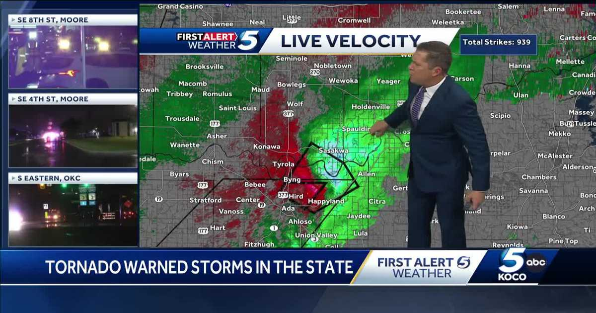
10:20 p.m. Saturday Update: A tornado warning was issued for Hughes, Pontotoc and Seminole counties until 11 p.m. The storm was located near Francis, moving northeast at 30 mph.
10:17 p.m. Saturday Update: A tornado warning was issued for a storm in Pontotoc County. A confirmed tornado was located near Francis, moving northeast at 20 mph.
10:05 p.m. Saturday Update: A tornado warning was issued for Pontotoc and Seminole counties for a storm located over Ada, moving northeast at 20 mph. Anyone in Ada should be in their shelter. Damon is live on Facebook.
10:01 p.m. Saturday Update: A tornado warning was issued for Pontotoc County for a storm located 4 miles north of Fitzhugh, moving northeast at 20 mph. Damon is live on Facebook.
9:57 p.m. Saturday Update: KOCO 5 Field Meteorologist Michael Armstrong is on the scene of a flooded vehicle on at OnCue near SW 4th Street and Interstate 35 in Moore.
9:48 p.m. Saturday Update: A tornado warning was issued for Pontotoc County until 10:30 p.m. A severe thunderstorm capable of producing a tornado was located near Fitzhugh, moving northeast at 15 mph. Damon is live on Facebook.
9:45 p.m. Saturday Update: A tornado warning was issued for Love County until 10:15 p.m. The storm was located 6 miles south of Burneyville, moving northeast at 35 mph, according to the National Weather Service.
9:40 p.m. Saturday Update: Moore police have responded to more than a dozen motorists assists due to flooding. Drivers are encouraged to stay off of the roads.
Heavy flooding is scene between Broadway and Tower Drive. There is also heavy flooding in neighborhoods, according to Moore police.
This content is imported from Twitter. You may be able to find the same content in another format, or you may be able to find more information, at their web site.
🚨BEWARE HIGH WATER🚨
MPD is working more than a dozen motorist assists involving vehicles stuck in high water. Multiple roads and neighborhoods have water over the curbs. Stay home if at all possible.#flooding pic.twitter.com/UDUm94MTdn
— Moore Police Dept. (@MoorePolice) April 20, 2025
9:32 p.m. Saturday Update: A tornado warning was issued for Carter, Johnston and Murray counties until 10:15 p.m. The warning was issued as a severe thunderstorm capable of producing a tornado is located near Ardmore. Damon is live on Facebook.
9:22 p.m. Saturday Update: A tornado warning has been issued for Garvin, Murray and Pontotoc counties until 10 p.m. The storm was located near Sulphur, moving northeast at 15 mph. Damon is live on Facebook.
A tornado watch was issued for Cleveland, Garvin, McClain, Pottawatomie and Seminole counties until midnight.
9:20 p.m. Saturday Update: Two severe thunderstorm warnings were issued for Garvin, Johnston, Murray and Pontotoc counties, and another in Carter, Jefferson and Love counties until 10 p.m.
There have been reports of flooding in southwest Oklahoma City, Moore and Norman.
9:04 p.m. Saturday Update: A tornado warning was issued for Carter County on the west side of Ardmore, headed east. The tornado warning was issued until 9:45 p.m.
9:01 p.m. Saturday Update: A severe thunderstorm warning was issued for parts of Love and Carter counties, including Ardmore. The severe storm could bring up to 70 mph winds and golf ball-sized hail.
8:57 p.m. Saturday Update: A new tornado warning was issued for northwestern Love County and southwestern Carter County until 9:45 p.m. A confirmed tornado was located 4 miles south of Wilson, moving northeast at 20 mph, according to the National Weather Service.
8:50 p.m. Saturday Update: KOCO 5 Chief Meteorologist Damon Lane is providing an update on the storm threat live on Facebook. Click here to watch.
At about 8:45 p.m., a confirmed tornado was located 7 miles north of Rubottom, moving northeast at 20 mph, according to the National Weather Service.
8:22 p.m. Saturday Update: A tornado warning has been issued for Love, Jefferson and Carter counties until 9 p.m.
8:10 p.m. Saturday Update: A tornado warning has been issued for Love and Jefferson counties until 8:30 p.m.
A strong thunderstorm located in northwest Oklahoma City is moving northeast at 20 mph. The storms could bring small hail, but they are not expected to be severe-warned.
The tornado threat remains for southern and southeastern Oklahoma.
7:50 p.m. Saturday Update: A flood warning was issued for Pottawatomie, Seminole and Atoka counties.
7 p.m. Saturday Update: A tornado watch has been issued for Atoka, Bryan, Carter, Coal, Hughes, Jefferson, Johnston, Love, Marshall, Murray, Choctaw, Pittsburg, Pushmataha and Pontotoc counties until midnight.
This content is imported from Facebook. You may be able to find the same content in another format, or you may be able to find more information, at their web site.
6:30 p.m. Saturday Update: KOCO 5 Meteorologist Sabrina Bates said the severe weather risk will continue through Saturday evening into early Sunday morning. The tornado risk is expected to stay closer to southern and southeastern Oklahoma.
A line of storms from Altus to Oklahoma City to Stillwater and Tulsa will see a level one marginal risk for severe weather. Ardmore, Ada and McAlester are areas that could see a level two slight risk for severe storms.
Hail could be as large as quarters, half dollars or even ping pong balls in the southern and southeastern parts of the state. But showers with embedded hail are expected across central and northern Oklahoma, moving quickly.
Storms could develop in southern Oklahoma between 7 p.m. and 9 p.m. Areas from Duncan, Sulphur, Ardmore and the Red River, including parts of Texas, will see storm development.
Get the latest news stories of interest by clicking here.
These storms will likely start to move northeast by around 10 p.m. to 11 p.m. Heavy rain will likely continue past midnight from Stillwater, OKC, Norman, down towards Pauls Valley and over to Seminole.
The rain will persist into early Sunday morning, particularly along I-35 and to the east.
For those attending sunrise services on Easter, heavy rain and storms may be encountered. That rain could continue into the afternoon.
Sabrina shows what to expect. Open the video player above for the timeline.
Be sure to download the KOCO 5 App to receive customized weather alerts. You can watch our team coverage on the app, too.
>> Check Live, Interactive Radar
>> Download the KOCO 5 App on iPhone
>> Download the KOCO 5 App on Android
>> Stream KOCO 5 weather updates anytime on the Very Local app