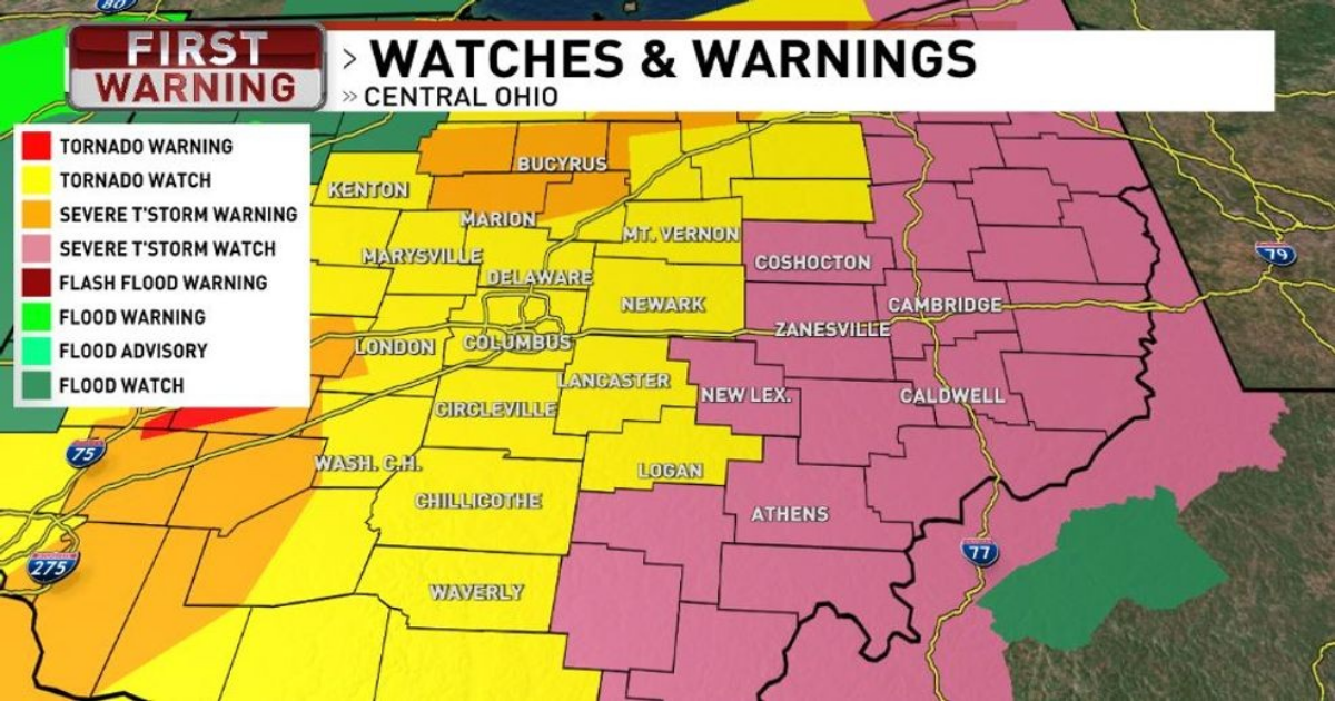
COLUMBUS, Ohio (WSYX) — A tornado watch was issued by the National Weather Service for parts of Ohio on Wednesday evening.
The watch is set to expire around 4 a.m. and is issued for parts of central Ohio, including Delaware, Fairfield, Fayette, Franklin, Licking, Madison, Pickaway, and Union counties.
WEDNESDAY PM ALERT: Another round of strong storms is likely to develop this evening and through the overnight hours. Central Ohio is likely to experience the strongest storms between 10 PM and 3 AM. Damaging winds, large hail, excessive rainfall, flooding, and isolated tornadoes will all be possible.
Stay #WeatherAware through the late night and overnight hours. Keep your mobile device charged and ready to receive watches and warnings. Double-check your emergency kit supplies. Have an emergency plan prepared and ready to implement.

ALSO | FORECAST | RADAR | SEND US YOUR WEATHER PHOTOS
FLOOD WATCH in effect through Sunday morning. Heavy rain falling on saturated ground is likely to create excessive runoff. Portions of Central Ohio may receive 4” to 6” of rain by Sunday morning. Rivers, creeks, and streams are expected to rise quickly, and flooding may occur. Low-lying and flood-prone areas should remain mindful of rising water. Avoid driving or wading through flood water. “Turn around, don’t drown.”
THURSDAY ALERT: showers and storms are possible during the day but the best opportunity for severe storms will be in the evening. This is another all-hazards setup with the potential for isolated tornadoes, hail, damaging winds, and flooding.
FRIDAY STORMS: more thunderstorms roll through the area on Friday; the best chance for severe storms will be in Central and Southern Ohio.
- TONIGHT: showers and thunderstorms, some storms may be strong to severe, low 62.
- THURSDAY: showers and thunderstorms, severe storms possible in the evening, warm, windy, high 71.
- FRIDAY: showers and thunderstorms, chance of isolated severe storms, breezy, cooler, high 62.
- SATURDAY: showers and thunderstorms, windy, warmer, high 72.
- SUNDAY: showers and occasional downpours, isolated thunder, cooler, windy, high 56.
- MONDAY: showers ending early, gradual clearing during the day, breezy, cooler, high 50.
- TUESDAY: partly cloudy, high 47.
- WEDNESDAY: partly cloudy, high 53.
MORE | Prepare your home | Watch vs. Warning
This is an “all-hazards” situation with the potential for damaging winds, heavy downpours, flooding, hail, and isolated tornadoes. Parts of Ohio are under an Enhanced Risk for severe storms, Level 3 or 5. (Indianapolis is at Level 4.) It will be important to remain vigilant and #WeatherAware tonight.

The actual cold front is a slow-mover and doesn’t arrive in Central Ohio until Thursday morning. And a weak, secondary front is likely to develop behind it. Showers and thunderstorms will be likely, on and off, during the day with another round of strong storms likely in Central and Southern Ohio Thursday evening. This will be another “all hazards“ situation, and we will need to remain vigilant again. Level 2 of 5.
Showers and thunderstorms are likely again on Friday, especially in Central and Southern Ohio, as the cold front stalls out near the Ohio River. A series of low-pressure centers will track along the then-stationary front, through the Ohio River Valley. There will be a chance for some isolated strong-to-severe storms (Level 1 of 5), especially in Southern Ohio on Friday. And storms will linger through Saturday, as well.
New low pressure drags into the Great Lakes on Sunday, pushing part of the lingering system to the east. A smaller, weaker front slips through the state on Monday, bringing in much cooler air. Showers will taper off before sunrise Monday and we’ll see some gradual clearing during the day. Sunshine arrives on Tuesday and Wednesday with merciful high pressure.